
Quadrant 1 Sea Breeze: Routing Considerations
Table of Contents
Quadrant 1 Sea Breeze Description
Introduction
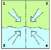
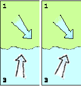
Four Sea Breeze Quadrants (Figure 1)
When considering a sea breeze and its probability of successfully developing, think of a typical coastline arranged as above with Quadrant 1 in the upper left hand corner and the wind from the northwest. A Quadrant 1 sea breeze is generally the strongest of the sea breezes, and therefore can have the greatest effects on the gradient wind.
NOTE: The example can be rotated in any direction to adapt to your own situation. As an example in Chicago, where the coastline runs north and south with the land to the west, rotating the quadrants 90 degrees counterclockwise would mean the Quadrant 1 example would rotate and the wind would be from the southwest in Chicago. Also, the examples provided are based on the Northern Hemisphere, but are equally valid in the Southern Hemisphere. For the Southern Hemisphere, change “left” to “right” and “right” to “left.”
The following description breaks down the formation of the sea breeze into its developmental stages.
Quadrant 1 Sea Breeze Description
1. Pre- Sea Breeze Stage
|
What the wind is doing |
|
How this affects your routing decisions. |
|
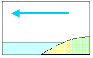
The gradient wind is predominant. Generally, the wind is light to moderate before the sea breeze fills in.
|
Figure 2
|
|
|
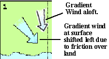
Friction from the land slows the surface wind and shifts it to the left in the Northern Hemisphere. |
Figure 3
|
Having a left shift closer to the beach may or may not suit your purposes. That will depend on which way you’re going and what you’re trying to accomplish. If you’re making landfall, it may mean that you’re better able to lay the mark as you get lifted on a port tack.
|
|
What the wind is doing |
|
How this affects your routing decisions. |
|
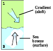
When the surface wind approaches the water, it turns right due to the lower significance of friction over the water; i.e., unaffected by the forces of friction over land, it becomes the direction of the true gradient wind.
|
Figure 4
|
As the wind goes further offshore, the reduced friction over water will allow the wind to shift right compared to the wind over the land. Therefore, wind along the beach will be somewhat more left than breeze further offshore. Do you want to be inshore or offshore? Here are some considerations:
|

2. Morning - Sea Breeze begins to develop
|
What the wind is doing |
|
How this affects your routing decisions. |
|
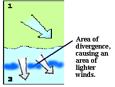
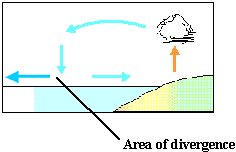
When the WNW meets the NW wind, it causes a natural divergence within 1-2 miles of the shoreline. This area of divergence creates an area of low pressure near the shoreline. Even if the NW gradient wind is blowing offshore at 10-12 kts, lighter winds develop along the shoreline.
|
Figure 5
|
Wind speeds within 1 – 2 miles from shore will probably be reduced due to the divergence of the wind as it goes over the water as well as the fact that you would be in the lee of the land, possibly sheltered from some of the wind. |
|
As the sun heats the land, air rises over the land and sinks in this area of divergence (low pressure).
|
Figure 6
|
At this point you need to have made your decision: Do you want to be on the landward side of the area of divergence, playing the sea breeze? Or do you want to be on the seaward side of the area of divergence, playing the gradient wind?
In order to determine where the outer edge of the sea breeze is, look for the calm patch – the area where the air is subsiding. This is the offshore area of divergence. Seaward of that calm area, the winds should favor the gradient wind direction. Landward of that area, the sea breeze should prevail |
|
What the wind is doing |
|
How this affects your routing decisions. |
|
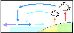
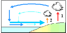
The gradient wind enhances the offshore flow of the sea breeze circulation aloft. As the wind aloft increases, the surface part of the circulation also increases.
|
Figure 7
|
The sea breeze is building in velocity and is expanding its coverage seaward. Keep in mind, however, that the sea breeze is a self-defeating system. As the cool air from the sea comes in over the land, it tends to cool that land along the coast. The way to keep track of whether or not the land is warm enough to support a sea breeze is to watch the clouds along the beach. If they are growing, the sea breeze is building. If the clouds are diminishing, the sea breeze is faltering.
|
|
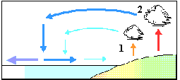
Before the first puffs of sea breeze are felt, the surface winds will be very light. The first puffs of the sea breeze are generally perpendicular to the coast.
|
Figure 8
|
Expect a shift from offshore winds (gradient winds), followed by a short time of lull, and then a gentle sea breeze to fill in perpendicular to the land. |
|
What the wind is doing |
|
How this affects your routing decisions. |
|
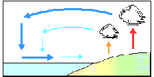
If the air continues to be unstable, the sea breeze circulation will grow larger and the sea breeze will become stronger, expanding further offshore.
|
Figure 9
|
As the morning progresses, expect a stronger sea breeze if the weather inland remains warm, and expect the offshore outer edge to move seaward.
NOTE: This may not be a constant increase. Quadrant 1 sea breeze circulation can go through a cycle of strengthening and weakening as it builds. Watch the clouds to determine how it is developing.
|
|
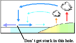
There will always be an area of wind holes between the inshore sea breeze and offshore gradient wind during a Quadrant 1 sea breeze. Do not get stuck in-between and in the wind holes.
|
Figure 10
|
Your strategy may take you seaward of this edge to find gradient wind, or shoreward of this edge to find the sea breeze. The problem is when you’re at the edge.
|
|
What the wind is doing |
|
How this affects your routing decisions. |
|
As the speed of the sea breeze increases and thus the forces of friction over both land and sea become more significant, the sea breeze over the water can rotate right, perhaps going as far right as to create a SW wind (in this example).
|
Figure 11
|
|
3. Afternoon - Sea Breeze begins to fade
|
What the wind is doing |
|
How this affects your routing decisions. |
|
If the ocean is cool, a surge of sea breeze will cool and stabilize the land, choking off the circulation.
This is the self-defeating nature of sea breezes: the cooling air from the water slows the sun’s warming process of the air over land.
|
Figure 12
|
Expect the sea breeze to decrease in speed. If you have been playing the sea breeze, you will want to work your way offshore at some point so that you are not trapped inside during the final dying stages of the sea breeze.
|
|
The sea breeze weakens, and then waits for another surge of rising air, which can be accompanied by a significant left oscillation, then builds again, etc. In order to get the right-hand / left-hand shifts, the sea breeze would need to be relatively charged up. If it’s a weak system, the wind may not shift around.
|
Figure 13
|
Make sure that you’re offshore prior to the sea breeze ending for the day. Getting back into the gradient can help you keep way on while others inshore are struggling with the dying sea breeze.
|
|
What the wind is doing |
|
How this affects your routing decisions. |
|
Eventually, as the sun begins to set the sea breeze will completely die.
|
Figure 14
|
The gradient will eventually return, but the boats on the shore will be the last to get it. Notice that the cumulus clouds have disappeared over land. |

©2004 L. Roberts and B. Biewenga
(203) 389-4440
Last Modified: April 23, 2004